Compliant drone operations
with every flight
SkyCompanion makes drone compliance easy with instant reports and outstanding data.
Have your operations category determined automatically
Detect air traffic heading towards you
Get mission protocols at the push of a button
Know where to fly – and where not
Learn about current events in your airspace
Compliant drone operations with
every
flight
SkyCompanion makes drone compliance easy with instant reports and outstanding data.
-
Get mission protocols at
the push of a button - Have your operations category determined automatically
- Know where to fly – and where not
- Detect air traffic heading towards you
-
Learn about current events
in your airspace
Legal drone operations – easy!
SkyCompanion makes compliant drone flights easy with an assisted determination of the operations category, automatically generated flight protocols at the push of a button and all necessary data in the highest quality in one single app.
You can plan missions in advance, check environmental conditions during flights and document your compliance to ensure legal drone operations.
Save up to 80 % planning effort
SkyCompanion helps drone pilots save valuable time by avoiding the hassle of gathering flight-relevant data from multiple sources.
In one single app, it provides you with the most comprehensive geo-zones, high-quality weather data from the German Weather Service (DWD), live air traffic with warnings and Remote ID, and official NOTAMs in readable language.
Boost your flight safety
SkyCompanion reduces the probability of errors by improving awareness for potential risks with its consistent package of high-quality data
Instead of hopping between different apps, improve the safety of your drone operations with all needed information in our all-in-one tool SkyCompanion.
Data API for mission planning
SkyCompanion's data and maps can be integrated as API into any mission planning software, such as QGroundControl or MissionPlanner.
Data API for mission planning
SkyCompanion's data and maps can be integrated as API into any mission planning software, such as QGroundControl or MissionPlanner.
Pricing for SkyCompanion
Try without risk with our 30-days-money-back guarantee
Monthly
Subscription
Most flexible
8.99 €
incl. VAT, per month
- Cancel anytime
- Full feature and data access
- Support by developer team
- Perfect for occasional use
Yearly Subscription
Save 25 %
79.99 €
incl. VAT, per year
- Best value
- Full feature and data access
- Support by developer team
- Perfect for regular use
SkyCompanion
for Teams
Volume discounts
Contact for offer
- Multi-user licenses
-
Centralized billing
(one invoice) - Assisted onboarding
- Perfect for operator teams
Pricing for SkyCompanion
Try without risk with our 30-days-money-back guarantee
Monthly Subscription
Most flexible
8.99 €
incl. VAT, per month
- Cancel anytime
- Full feature and data access
- Support by developer team
- Perfect for occasional use
Yearly Subscription
Save 25 %
79.99 €
incl. VAT, per year
- Best value
- Full feature and data access
- Support by developer team
- Perfect for regular use
SkyCompanion for Teams
Volume discounts
Contact for offer
- Multi-user licenses
-
Centralized billing
(one invoice) - Assisted onboarding
- Perfect for operator teams
FAQ
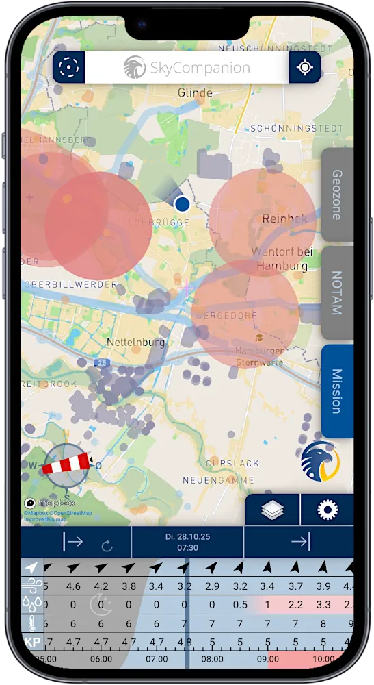
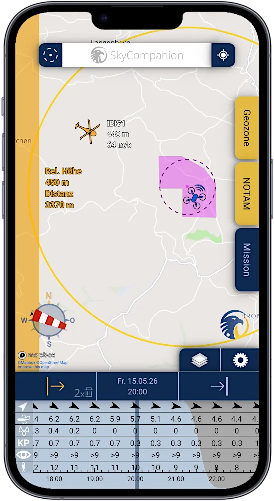
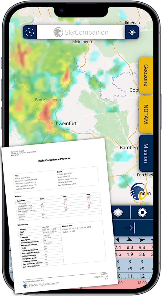
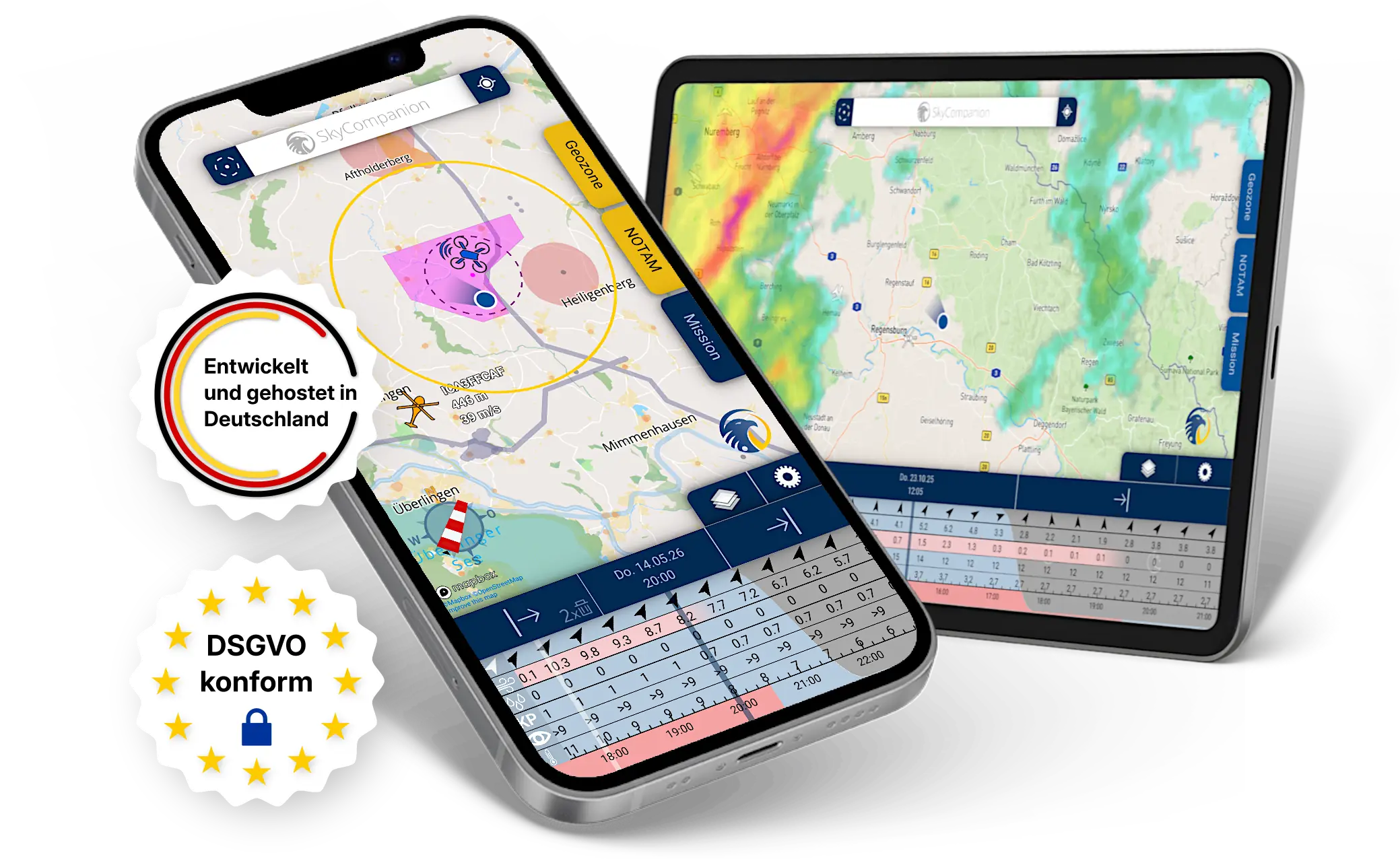
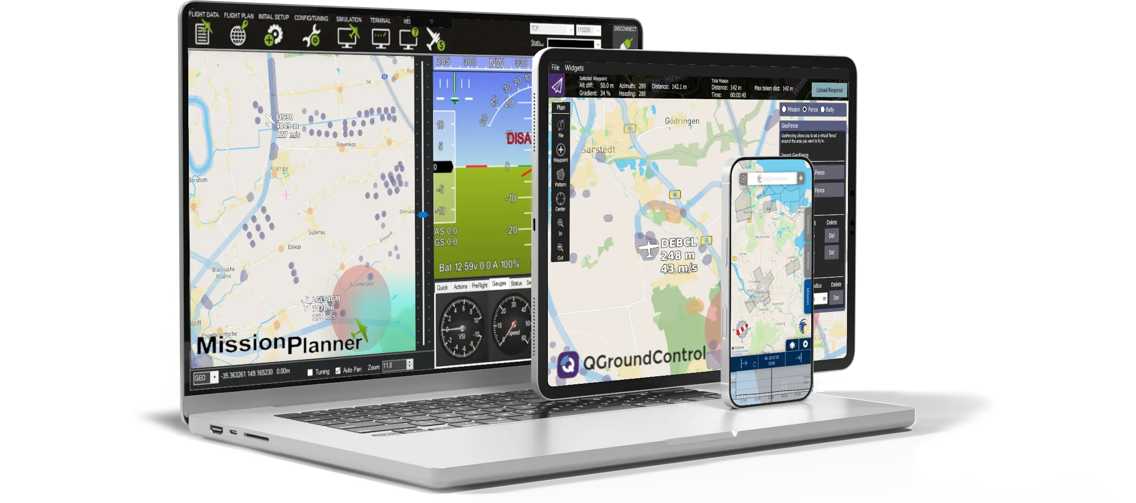
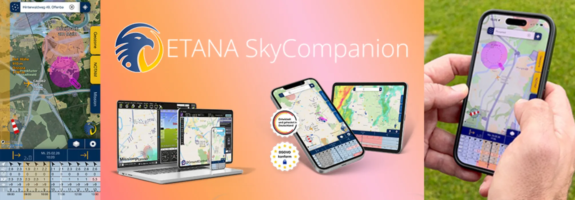
What is SkyCompanion and who is the app for?
SkyCompanion is a simple and convenient tool for drone pilots to ensure legal drone operations and improve flight safety by consolidating all necessary information into a single app and by automating the documentation process.
Details: SkyCompanion supports you in safe and compliant flight preparation, during missions, and in post-flight review. On its map, you see geo-zones (a.k.a. no-fly-zones), current airspace advisories (including NOTAMs), weather data, and nearby air traffic including remote IDs. You can plan missions with location and time, determine your operations category and automatically document them as a PDF protocol. This way you have all essential information for drone operations in one app – for both private and professional drone pilots.
Try risk-free today:
Apple App Store
Google Play
Updated: Oct 27th, 2025
Does SkyCompanion show me where I am allowed to fly with my drone?
Yes. SkyCompanion shows drone pilots where they are allowed to fly and where they are not. It displays geozones and restricted airspace that limit or prohibit drone flying with distinctive, colorful markings on the map.
Details: Geo-zones are geographical areas in which regulations and restrictions apply for the operation of drones, e.g. hospitals, industrial areas or nature reserves. In SkyCompanion you can display geo-zones on the map and find detailed information for the geo-zones in your mission area. Furthermore, restricted airspaces are displayed in which drone operations may also be limited, e.g. airport control zones. This helps you quickly assess whether a flight in your desired area is allowed and under what conditions.
Try risk-free today:
Apple App Store
Google Play
Updated: Oct 27th, 2025
Can SkyCompanion tell me what rules I need to follow when flying a drone?
Yes, SkyCompanion provides an overview and tips on important rules that you must follow when flying your drone.
Details: When preparing your mission, practical explanations will help you understand how your plans affect your operating category and what constraints you must adhere to during your flights, e.g., distances from people, flight speeds, flight altitudes, and much more.
Try risk-free today:
Apple App Store
Google Play
Updated: Oct 27th, 2025
Can I use SkyCompanion to determine the category of my drone flights?
Yes, SkyCompanion automatically determines which (sub)category you are flying in based on the information you provide, e.g., Open Category A1.
Details: According to EU Implementing Regulation (EU) 2019/947, every drone flight takes place in a certain category, which is determined based on the respective operational risk. Different conditions and restrictions apply to drone operations depending on the category. SkyCompanion provides an assisted questionnaire to help you determine the correct (sub)category for your flight mission. This feature is currently available for drone flights in the Open Category. A feature for determining a SAIL level in the Specific Category is not yet available.
Try risk-free today:
Apple App Store
Google Play
Updated: Oct 27th, 2025
Can I log flights and document them as PDF?
Yes. SkyCompanion automatically generates mission protocols as PDF with relevant mission data.
Details: For each mission, you can create a PDF flight protocol by tapping the export button on the mission ribbon. The protocol includes key mission details, the operations category, affected geozones, relevant NOTAMs in the area, and selected weather metrics (min/max values). This makes documentation, approvals and audits easier – especially for professional use.
Try risk-free today:
Apple App Store
Google Play
Updated: Oct 27th, 2025
Does SkyCompanion inform me about airspace restrictions (NOTAMs)?
Yes. SkyCompanion shows relevant airspace notices and restrictions from official publications on the map (e.g. ED-R) and current NOTAMs in readable language.
Details: NOTAMs (Notice to Air Missions) provide information about temporary changes in airspace, e.g., short-term closures or special activities. SkyCompanion links your mission area with current NOTAMs and displays them on the map with essential details. We provide to you both the official NOTAMs with the common aviation abbreviations as well as an enhanced version in clear, readable language. This gives you an overview of temporary restrictions already during planning.
Try risk-free today:
Apple App Store
Google Play
Updated: Oct 27th, 2025
Does SkyCompanion warn me about other air traffic?
Yes, SkyCompanion issues warnings when air traffic approaches your mission area. For this purpose, it uses high-quality data from ADS-B Exchange, the world’s largest tracking network.
Details: If you have defined a mission area on the SkyCompanion map and an aircraft approaches it, you will receive a visual warning in form of an orange flashing box in the relevant compass direction. These warnings appear when the foreign aircraft is within 5,000 m of your mission area and has a maximum altitude difference of 1,500 m.
Try risk-free today:
Apple App Store
Google Play
Updated: Oct 27th, 2025
Does SkyCompanion display Remote IDs of nearby drones?
Yes. SkyCompanion can receive and display Remote IDs nearby.
Details: According to EU Implementing Regulation (EU) 2019/947, drones of all classes—with the exception of C0 and C4—must be operated with active remote identification (Remote ID). This is an electronic identifier for the drone that can be accessed by other devices via Bluetooth or Wi-Fi, e.g. using an app. SkyCompanion also displays remote IDs of nearby drones on the map. On Android, Remote ID reception requires active Wi‑Fi or Bluetooth. On iOS, reception requires Bluetooth. On the map, you see detected unmanned aircraft within range dispayed with their Remote ID, enhancing situational awareness during missions. Note that range/availability depends on your device, environment, and transmission settings.
Try risk-free today:
Apple App Store
Google Play
Updated: Oct 27th, 2025
Does SkyCompanion provide me with weather information?
Yes, SkyCompanion offers precipitation radar for the past 6 hours and the next 2 hours, as well as weather data for the past 6 months and the next 10 days.
Details: SkyCompanion provides high-quality weather data from the German Weather Service (DWD) in a well-structured format. Use the precipitation radar to explore the current rain or snow situation in your flight area for the past 6 hours and the next 2 hours. In the time and weather bar, the app also displays the most important weather data from the DWD weather models: wind speed and direction, gusts, temperatures, precipitation amounts, KP index. This weather data is displayed for the past 6 months and the next 10 days and is documented for your mission area in the PDF mission protocol.
Try risk-free today:
Apple App Store
Google Play
Updated: Oct 27th, 2025
What is the quality of the data in SkyCompanion?
We only use highest quality data from official registers and established primary sources, regularly updated for our users.
Details: SkyCompanion provides the most comprehensive and most current geo-zones in the market, which are being assembled meticulously from official authority registers. Weather data is provided by the German Weather Service (DWD). Live air traffic data is derived directly from aircraft transponder signals – aggregated by the worldwide largest tracking network ADSB Exchange. NOTAMs are received from official ICAO publications. This way you get robust and practical information for your flight preparation.
Remarks: Currently, data availability is limited to Germany; availability and topicality of the data may be temporarily limited due to technical or other reasons.
Try risk-free today:
Apple App Store
Google Play
Updated: Oct 27th, 2025
Does SkyCompanion work offline?
Yes, key functions like mission planning and determination of operations categories are available offline; live data (e.g., NOTAMs, weather, traffic) require an internet connection like in any other data related app, too.
Details: You can plan missions, use saved map areas, and prepare flights without a connection. However, without internet, live information is not updated: uncached map date, current weather, live traffic, new NOTAMs. For final pre-flight checks, we recommend going online in SkyCompanion to ensure you have the latest data.
Try risk-free today:
Apple App Store
Google Play
Updated: Oct 27th, 2025
How do I start my first mission with SkyCompanion?
The tutorial with guided instructions launches automatically on first start; you can reopen it anytime from the settings menu.
Details: Launch SkyCompanion, follow the guided tutorial, and set up your first mission in a few steps:
- Navigate to the map area where you want to fly and place your mission area on the map by tapping and holding
- Set the size of the mission area with the arrow shaped slider element
- In the time bar specify start and end time of your mission with the arrows left and right
- Go to the mission tab, enter the title and save your first mission
Adjust your mission setting and determin your operations category with the pencil icon. You can check geo-zones and NOTAMs for your mission in the according tabs. If you want to document your mission you can save a flight protocol as PDF with a tap on the export button on the mission ribbon.
Try risk-free today:
Apple App Store
Google Play
Updated: Oct 27th, 2025
Which devices and operating systems does SkyCompanion support?
Supported are smartphones and tablets with Android from version 9 or iOS from version 16.
Details: SkyCompanion is optimized for modern smartphones. On Android, at least Android 9 is required; on iPhones, at least iOS 16. For best performance and security, we recommend to update your operating system to the latest version available to you. Older devices or beta versions may show differences in functionality.
Try risk-free today:
Apple App Store
Google Play
Updated: Oct 27th, 2025
How secure is my data in SkyCompanion?
SkyCompanion is GDPR-compliant; we do not share user data. App data stays on the device, servers are located in Germany.
Details: Data protection and data minimization are core principles of our work. The SkyCompanion app itself does not collect or share personal user data with third parties except for mandatory data within the subscription process of the according app store.
The app data, e.g. mission data, settings remains on your device. Server-side components, e.g. geo-zones, weather are hosted on German servers. Details are available in our privacy policy. For additional security (e.g., device lock, OS updates), we recommend standard best practices.
Try risk-free today:
Apple App Store
Google Play
Updated: Oct 27th, 2025
Can I try SkyCompanion risk-free?
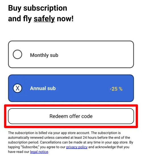
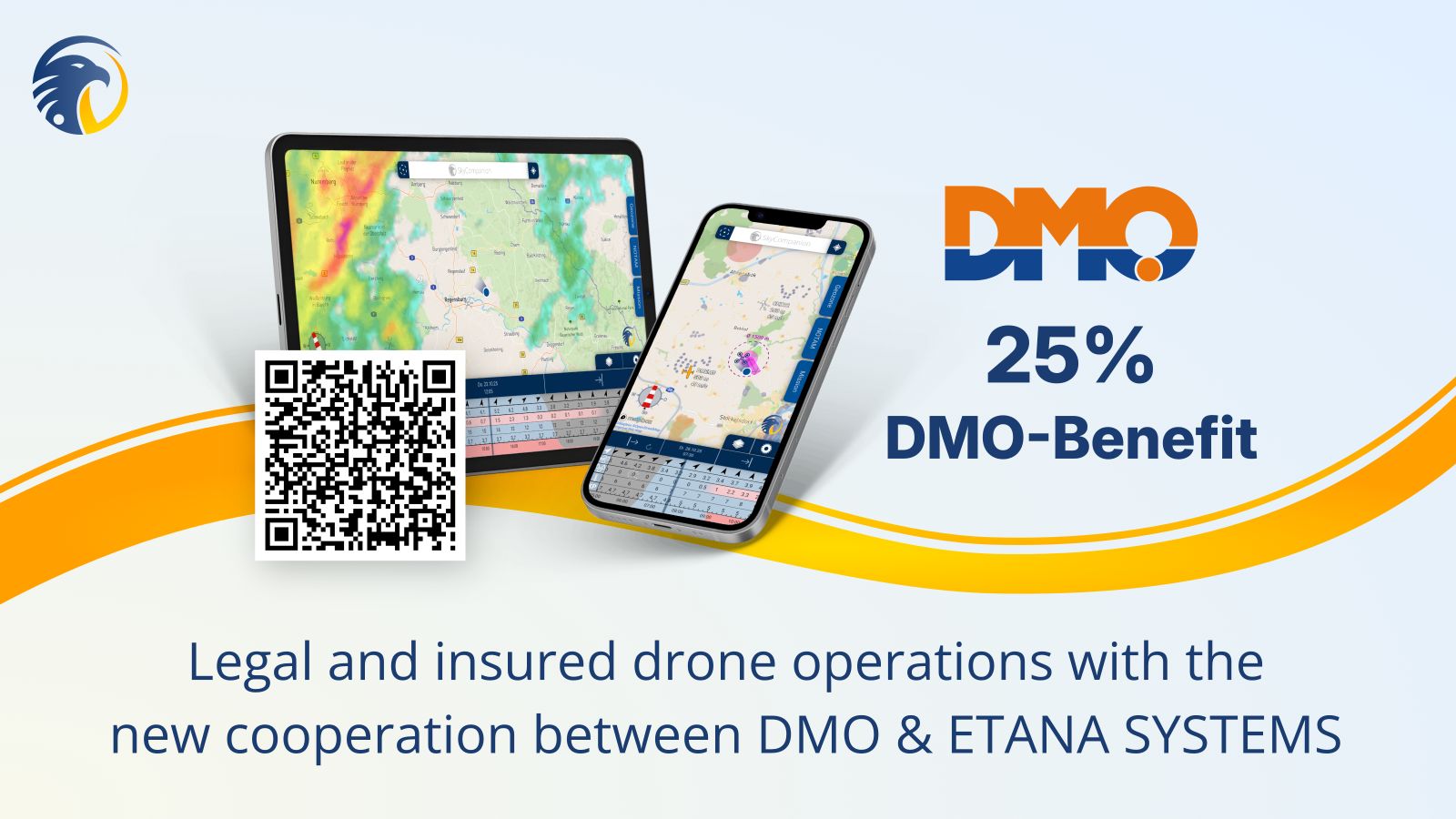
Yes. You have a 30‑day money-back guarantee on every subscription.
Details: You can try SkyCompanion with peace of mind: Within 30 days of purchase, any subscription can be canceled and you will receive a full refund. Refund processing depends on where you purchased – via Apple App Store, Google Play, or directly through ETANA SYSTEMS (e.g., for volume licenses). In case of any questions regarding your subscription, please contact us anytime and we will reach out to you quickly. Feel free to use the contact form on the bottom of this page.
Try risk-free today:
Apple App Store
Google Play
Updated: Oct 27th, 2025
How can I cancel a subscription (and receive an invoice)?
Store purchases are canceled in your App Store account; direct licenses via email to info@etana-systems.com.
Details: If you purchased a subscription through the App Store or Google Play, you manage and cancel your subscription directly in your store account. For direct purchases (e.g. team/volume licenses), please contact info@etana-systems.com – we will handle the cancellation as soon as possible in writing.
Invoices are provided either by the respective app store or directly from ETANA SYSTEMS for direct licenses.
Try risk-free today:
Apple App Store
Google Play
Updated: Oct 27th, 2025
Further questions?
Leave a quick message and we will reach out to you in short time.